|
| Background |
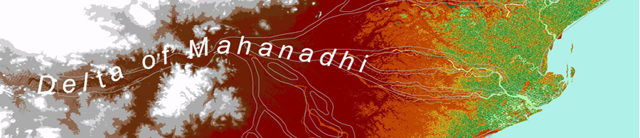
River
Deltas are one of most principal coastal landforms and
important areas for humans ecologically and economically.
Damming rivers has slowed the flow of sediment that would
replenish land. Most of the world's major river deltas
are sinking, increasing the flood risk faced by hundreds
of millions of people, scientists report. Damming and diverting
rivers means that much less sediment now reaches many delta
areas, while extraction of gas and groundwater also lowers
the land. Rivers affected include the Colorado, Nile, Pearl,
Rhone and Yangtze. |
| THE HIGH-RISK
DELTAS |
| Deltas with "virtually
no aggradation (supply of sediment) and/ or very high
accelerated compaction" |
Ganges-Brahmaputra,
India- Bangladesh
Chao Phraya, Thailand Colorado, Mexico
Krishna, India
Nile, Egypt
Pearl, China
Po, Italy
Rhone, France
Sao Francisco, Brazil
Tone, Japan
Yangtze, China
Yellow, China |
|
About
half a billion people live in these regions, and it is
estimated that 85% of major deltas have seen severe flooding
in recent years, and that the area of land vulnerable to
flooding will increase by about 50% in the next 40 years
as land sinks and climate change causes sea levels to rise.
It is argued that the world's low-lying deltas are increasingly
vulnerable to flooding, either from their feeding rivers
or from ocean storms.
|
Deltaic
coasts are affected by changes both on the land (in the drainage
basin) and in the ocean. A sea -level rise and tsunami are
typical examples of changes in the ocean that may severly
affect the coastal zones. |
|
Decreases in sediment and
water discharge caused by dam construction, sand dredging in
river channels, and water usage in drainage basins are typical
examples of changes on the land that also impact coasts. Increase
of elements transported through rivers also impacts ecosystem
and biogeochemical cycles in the coastal zones.
Of the 33 major deltas studied, 24 were found to be sinking.
Possibly the worst affected is the Chao Phraya, the river that
flows through Bangkok. In some years, parts of the delta have
sunk relative to sea level by 15cm (six inches). This is significantly
more than the global rate of sea level rise as a consequence
of climate change (1.8-3.0mm per year). The flow of sediment
down to the Chao Phraya delta has been almost entirely blocked,
the researchers report - by taking water out for irrigation,
damming the river, and directing the main flow through just a
few channels.
Normally, this sediment would add to the height of the land,
a process known as aggradation. Taking water from aquifers for
drinking, industry and agriculture is also compacting the ground,
making it sink. As the ground falls and sea level rises, people
become more vulnerable to inundation during storms. Every year,
about 10 million people are being affected by storm surges. "Hurricane
Katrina may be the best example in the US, but flooding in the
Asian deltas of the Irrawaddy in Burma and the Ganges-Brahmaputra
in India and Bangladesh have recently claimed thousands of lives
as well.
Continental materials are transported to oceans through deltas.
Deltas play an important role between lands and oceans. Asian
coasts are characterized by large-river deltas, which is called
megadeltas in IPCC Fourth Assessment Report 2007, and indicated
as one of more vulnerable areas related to global climate changes.
Shrinking and sinking deltas are on-going problems globally. |
|
|